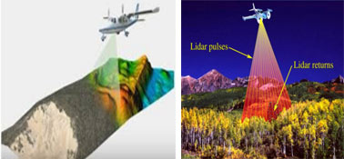
What is LiDAR Technology
Credit: 10 PDH Hours
Course Fee: $90.00
77 pages
How it Work!
- Register first and log into your account. Study and take the quiz for FREE until passed.
- After passing the quiz, follow the page, pay for the course and print your certificate.
Course Summary:

Learning Objective:
Lidar, as a remote sensing technique, has several advantages. Chief among them are high accuracies, high point density, large coverage areas, and the ability of users to resample areas quickly and efficiently. This creates the ability to map discrete changes at a very high resolution, cover large areas uniformly and very accurately, and produce rapid results. In this course we will learn how LiDAR works.
Review the quiz before studying the course.
Course Content
Course Author: NOAA
Certificate of completion of the course
This course comes with a multiple-choice quiz. You can view the quiz and take the quiz if you are logged in your account. You can take the quiz for this online PDH course as many times until passed. The passing grade is 70% and above. After you pass the quiz simply follow the page, to pay for the course and print your certificate instantly. A copy of the certificate and receipt for this course will always be in your account.
This online PDH course can also be used as a continuing education course for the following.
